Randonnée Marche Sarroux - Saint-Julien - le site de Saint-Nazaire - Photo
 viam19
viam19

Utilisateur

© OpenStreetMap contributors
Longueur
Longueur
14,2 km
Altitude max
Altitude max
644 m
Dénivelé positif
Dénivelé positif
249 m
Km-Effort
Km-Effort  
17,6 km
Altitude min
Altitude min
543 m
Dénivelé négatif
Dénivelé négatif
249 m
Boucle
Boucle
Oui
Date de création :
2020-02-15 08:56:46.606
Dernière modification :
2020-02-15 21:51:01.255

(0 Avis)

Marche
Marche
5h36
Difficulté : Facile

Scannez ce code QR pour ouvrir la randonnée dans l'application SityTrail

Application GPS de randonnée GRATUITE

Logo SityTrail SityTrail

IGN / Instituts géographiques

Télécharger SityTrail sur l'App Store Télécharger SityTrail sur Google Play

Logo SityTrail SityTrail World

Le monde est à vous

Télécharger SityTrail sur l'App Store Télécharger SityTrail sur Google Play Télécharger SityTrail sur Huawei AppGallery

À propos

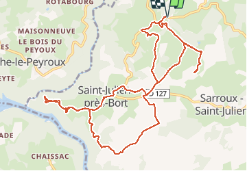
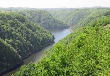
Randonnée Marche de 14,2 km à découvrir à Nouvelle-Aquitaine, Corrèze, Sarroux - Saint-Julien. Cette randonnée est proposée par viam19.

Description

Randonnée en boucle.
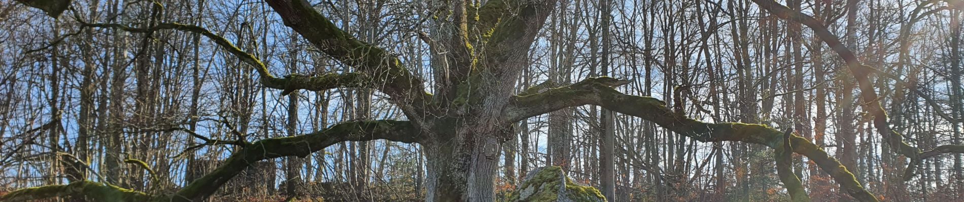
Aller et retour au chêne des anglais (arbre remarquable) au village de la Fourcherie, environ 1 km.

Profil altimétrique

Photos

Localisation

Pays :
France
Région :
Nouvelle-Aquitaine
Département/Province :
Corrèze
Commune :
Sarroux - Saint-Julien
Localité :
Saint-Julien-près-Bort
Départ:(UTM)
454363 ; 5030854 (31T) N.

Randonnées à proximité

Randonnée Marche Sarroux - Saint-Julien - Un air de montagne - Sarroux - Photo
Marche
tracegps

Marche

Moyen
(1)
Sarroux - Saint-Julien, Nouvelle-Aquitaine, Corrèze, France
16 km | 21 km-effort
4h 30min
Oui
Randonnée Marche Sarroux - Saint-Julien - La Pyramide, le château Pierrefitte, les Orgues - Photo
Marche
grageot

Marche

Facile
(2)
Sarroux - Saint-Julien, Nouvelle-Aquitaine, Corrèze, France
15,6 km | 23 km-effort
4h 28min
Oui
Randonnée Marche Bort-les-Orgues - Bort-les-Orgues - Photo
Marche
houbart

Marche

Moyen
Bort-les-Orgues, Nouvelle-Aquitaine, Corrèze, France
5 km | 7,2 km-effort
1h 37min
Oui
Randonnée Marche Sarroux - Saint-Julien - Saint-Julien-près-Bort - Photo
Marche
houbart

Marche

Facile
Sarroux - Saint-Julien, Nouvelle-Aquitaine, Corrèze, France
5,1 km | 6,3 km-effort
1h 23min
Oui
Randonnée Marche Bort-les-Orgues - SityTrail - Bort-les-Orgues 5,2km - Photo
Marche
vitius

Marche

Moyen
Bort-les-Orgues, Nouvelle-Aquitaine, Corrèze, France
5,2 km | 7,6 km-effort
1h 43min
Oui
Randonnée Marche Margerides - margerides Fred B C - Photo
Marche
arnoultjf

Marche

Moyen
Margerides, Nouvelle-Aquitaine, Corrèze, France
9 km | 11,7 km-effort
2h 39min
Oui
Randonnée Marche Sarroux - Saint-Julien - E 4 Lagrange_Roche le Peyroux. - Photo
Marche
viam19

Marche

Difficile
Sarroux - Saint-Julien, Nouvelle-Aquitaine, Corrèze, France
13,6 km | 18,1 km-effort
4h 7min
Non
Randonnée Marche Roche-le-Peyroux - Itinereve 2 - Photo
Marche
dnbo79

Marche

Très difficile
Roche-le-Peyroux, Nouvelle-Aquitaine, Corrèze, France
45 km | 59 km-effort
9h 0min
Non
Randonnée Marche Saint-Pierre - st Pierre - Photo
Marche
Michelraimbault

Marche

Facile
Saint-Pierre, Auvergne-Rhône-Alpes, Cantal, France
8,2 km | 10,9 km-effort
2h 22min
Oui


Fermer
Mes abonnements